More precipitation in the northern region, continuous heat in the south of the Sichuan Basin, important weather
1. More precipitation in the northern region
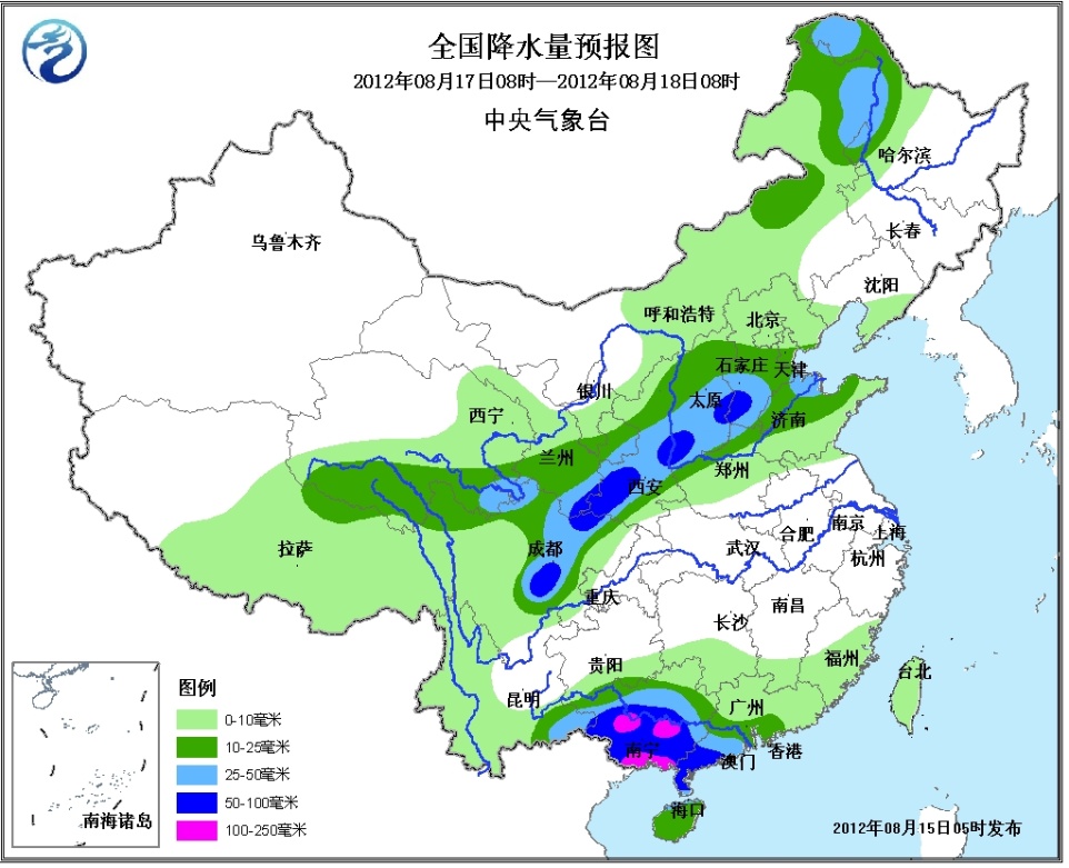
From 16 to 17th, there will be a precipitation weather process in the eastern part of the northwestern region, Inner Mongolia, the western part of the northeastern region, northern China, northern Huanghuai, eastern Qinghai-Tibet Plateau, and Sichuan Basin. Among them, western Inner Mongolia, eastern Qinghai, southern Gansu, southern Ningxia, Heavy rain occurred in parts of Shaanxi, Shanxi, southern Hebei, and western Sichuan Basin, and there was heavy rain in the local area.
2. Sichuan Basin will continue to have high temperatures
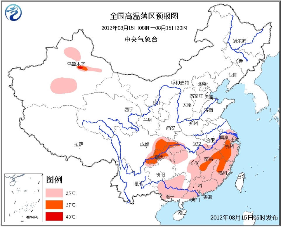
From 15 to 17 days, the Sichuan Basin, most of the Jiangnan, and northern China will continue to have high temperature above 35 °C. The highest temperature in some areas can reach 37-39 °C.
3. “Kai Tak†continues to move northwest. Tropical Storm “Kai Tak†on the 13th has been strengthened into a strong tropical storm on the 14th of the 14th in Luzon, Philippines. It was in the Luzon Island of the Philippines around the time of 14:00 on the 15th. Landing near the coast of Lanan, the maximum wind force near the center is 10 (25 m / s), the lowest pressure in the center is 988 hPa. At 0500, the center is still located near Palanan in Luzon, Philippines. It is 17.1 degrees north latitude and 122.4 degrees east longitude. The maximum wind force near the center is 10 (25 m/s), and the lowest pressure in the center is 988 hectopascals. It is estimated that "Qingde" will continue to move northwestward at a speed of about 20 kilometers per hour, passing through the Luzon Island of the Philippines, and will enter the northeastern part of the South China Sea on the evening of the 15th, and gradually approach the coast of Guangdong, and the intensity will gradually strengthen.
Second, the specific forecast for the next three days
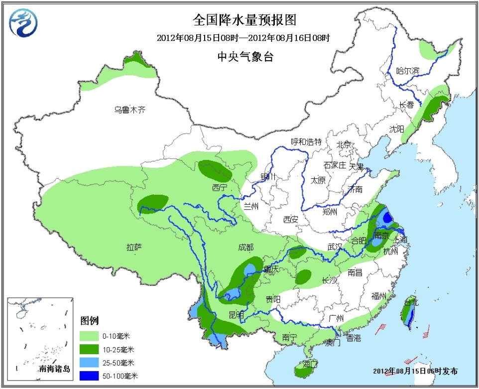
From 08:00 to 16:00 on the 15th, there were small to moderate rains or thunderstorms in the Qinghai-Tibet Plateau, northern Xinjiang, western Gansu, eastern Jilin, eastern Liaoning, central and eastern Jianghuai, northern Jiangnan, southwest, south China, and Taiwan. In the southwestern part of the Sichuan Basin, the western and southern parts of Yunnan, the south-central part of Jiangsu, the southeastern part of Anhui, and the eastern part of Taiwan, there are heavy rains and local heavy rains (50-90 mm). These areas are accompanied by strong convection such as thunderstorms and strong winds. the weather. Affected by the "Qi De", Taiwan's east sea surface, the bus strait, and the northeastern part of the South China Sea will have 7 to 9 winds and gusts of 10 to 11 winds. The winds in the nearby waters of the Kai Tak Center will have 9 to 10 winds. The level and gust can reach 11 to 12 levels. There will be 6 to 8 northeast winds in the southern seas of the East China Sea and the Taiwan Strait. There will be 6 to 7 northwest winds in the central and eastern waters of the South China Sea. 

From 08:00 to 17:00 on the 16th, there were moderate to heavy rains in the western part of Inner Mongolia, the eastern part of Northwest China, the northwestern part of North China, the eastern and southern part of Qinghai, and the central and eastern parts of southern China, including western Inner Mongolia, northwestern Shaanxi, southern Gansu and southern Guangdong. There are heavy rains in some areas, and heavy rains (100-180 mm) in the southern part of Guangdong; some of the above areas are accompanied by strong convective weather such as thunderstorms and strong winds. Affected by Kai Tak, the bus strait and the northeastern part of the South China Sea will have 8-10 winds and 11-12 winds. The winds in the nearby seas of the Kai Tak Center will have 11 to 12 winds and gusts. At level 13, the Taiwan Strait will have 6-8 winds. 
From 08:00 to 18:00 on the 17th, there were moderate to heavy rains in northeastern Inner Mongolia, western Heilongjiang, eastern northwest, north-central North China, northeastern Huanghuai, central and western Sichuan Basin, western and southern South China, and southeastern Yunnan. Among them, there are heavy rains in parts of the western Sichuan Basin, southeastern Gansu, southwestern Shaanxi, southwestern Shanxi, southwestern Hebei, southwestern Guangxi, southwestern Guangdong, etc., and heavy rains (100-160 mm) in the central and southern parts of Guangxi; The area is accompanied by strong convective weather such as thunderstorms. Affected by the "Qingde", the northern part of the South China Sea and the bus strait will have a southwesterly wind of 6 to 7 and a gust of 8 winds. 
Medical Grade Caster,Medium Duty Hospital Caster,Twin Wheels Medical Caster,Stem Medical Caster
Guangzhou Weihang Caster Co., Ltd. , https://www.factory-metal.com